
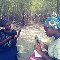
Local communities in the Global South can now lead their own CDR projects and actually be heard—something that doesn't happen nearly enough.
We give them the tools: live data collection, proper education, and real financial incentives. This means they're not just participating—they're owning these projects and shaping their own futures. Meanwhile, companies get to make a genuine, sustainable impact.
Empower Communities to Drive Projects
COMMUNITY-LED dMRV PLATFORM
Why Choose CitizenClimate?
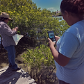
Get communities involved in proper citizen science research
They collect live data on everything from their daily activities and project work to environmental changes happening around them. Our AI identifies animals, plants, crop health, fish, mushrooms, and insects—all the things that matter locally.
This way, they're contributing to global studies whilst picking up valuable skills and securing funding that makes a real difference in their own communities.
Biodiversity Verification
Utilizing AI species recognition to log species sightings by local communities. Integrated dashboards correlate wildlife density with habitat restoration metrics.
PLATFORM VALUE
Why we build CitizenClimate
[01]
Transparency
Decentralized data streams ensure every climate metric is traceable, public, and immutable for all stakeholders.
[02]
Credibility
Rigorous AI verification cross-references field reports with global carbon standards for institutional-grade integrity.
[03]
Empowerment
Fair digital incentives directly reward local communities for their stewardships, fostering long-term project success.
Quantifying Real-World Impact Across Sustainable Development Goals
Automated scoring platform that converts raw community data into verifiable impact certificates and SDVista metrics.
Real-World Climate Projects Powered by Community Data
Empowering local communities to monitor, report, and verify climate impact through specialized digital solutions.


We've always wanted to give communities a real stake in projects where they usually have no say.
Our app puts them in charge—through data collection, education, and financial support—so they're not just taking part, they're actually building prosperity.
Why CitizenClimate?
Conservation shouldn't be locked away in labs and universities—it belongs to everyone. We're changing how ecosystems get protected by putting communities at the front. Here's what makes us different:

Transparency You Can Trust
Every tree measured, every species tracked, every drop of water tested—all our data is open and accessible. You can see the impact of your work in real-time through straightforward reports, maps, and updates. No secrets, no hiding behind jargon. Just actual results you can see.
Credibility That
Counts
Our verification process is thorough—peer reviews, expert audits, smart tech working together—so every data point holds up. Whether it's local observations or meeting global standards, we're delivering conservation data you can actually trust.
Empowering Communities
You're not just someone using an app—you're making real change happen. CitizenClimate gives you intuitive tools, proper training, and an actual voice in how things work. You get to protect your environment and shape what comes next. Your knowledge matters. Your impact is real.
Leaderboard & Badges
Gamified contributor rankings with badges across categories. Monthly and all-time leaderboards drive sustained engagement. Builds engagement and ensures sustainable participation.

Platform Capabilities
Empowering environmental stewardship with enterprise-grade digital MRV infrastructure.


Interactive lessons that build knowledge and earn points
Illustrated lessons with infographics teach disease prevention, sustainability practices, and environmental awareness. Each lesson ends with a scored quiz — earn points for every correct answer.
-
Rich lesson content with illustrated infographics
-
Multiple-choice quizzes with instant feedback
-
Detailed explanations for every answer
-
Score tracking with points per quiz completion
-
Badge progression: Learner → Scholar → Expert

METHODOLOGY
The dMRV Lifecycle
Step [01]
Monitor
Communities utilize our offline-first application for decentralized data collection. Empowered by AI-assisted species recognition and custom surveys, field teams track biodiversity and carbon metrics directly at the source.
Step [02]
Report
Encrypted data is synchronized to our central platform for automated processing. AI photo verification and location metadata analysis transform community observations into credible, auditable digital assets with full transparency.
Step [03]
Verify
Project performance is cross-referenced against global carbon standards in real-time. Successful verification triggers instant tokenized incentives, ensuring fair and direct compensation for project stakeholders.
A space for your community to connect and share
Community-driven discussion boards where members share observations, post photos, comment, and like — all organised by project and topic.
-
Photo and text posts with image attachments
-
Threaded comments with likes and engagement
-
Searchable posts filtered by community or project
-
Report and moderation tools for project admins
Aligned with all international standards:
Pricing
Tier | Max Users | AI Credits incl./mo | Monthly Price | Annual Price (10% disc.) |
|---|---|---|---|---|
Free | 100 | 0 | Free | Free |
Pro | 500 | 1000 | $299.00 | $3228.00 |
Growth | 1000 | 3000 | $599.00 | $6468.00 |
Scale | 5000 | 8000 | $1199.00 | $12948.00 |
Carbon project verification costs are rising. So are buyer expectations around community benefit evidence.
CitizenClimate gives you the monitoring infrastructure to meet both — at a fraction of what traditional MRV costs. A project generating 20,000 credits per year at $20 per tonne earns $400,000 annually. Our Pro plan at $299/month works out to less than 1% of that revenue, while the dMRV data it produces can increase your credit prices by 10–30% (SustainCERT, 2023).
Competitive Advantage
Category | CitizenClimate | Data Collection App | Survey App | Enterprise dMRV |
|---|---|---|---|---|
Focus | Carbon dMRV + SDG | Humanitarian surveys | Field data collection | Satellite / IoT MRV |
AI Identification | Yes (5 types) | No | No | Partial |
SDG Pro Metrics | Yes | No | No | Varies |
Gamification | Yes | No | No | No |
Offline mobile | Yes | Yes | Yes | No |
Community-first design | Yes | Partial | No | No |
Typical price (500 users) | $299/mo | $166/mo | ~$400/mo | $2k-10k/mo |
CitizenClimate sits between general-purpose survey tools (which lack carbon-specific features entirely) and enterprise satellite platforms (which start at many times the price). If your project needs structured SDG monitoring, biodiversity surveys, grievance tracking, and community engagement in a single platform built specifically for carbon and conservation verification — there isn't a comparable product at this price point.


FAQ
What is dMRV technology?
dMRV stands for digital measurement, reporting and verification. It's a modern approach to tracking environmental impact using technology. Unlike traditional manual data collection methods, dMRV technology combines remote sensing, automated monitoring, and community-led verification processes to measure carbon impact accurately. This ensures transparency and accountability whilst making data accessible in real time for project developers and stakeholders in carbon markets.
How does CitizenClimate verify carbon credits?
We use a hybrid approach that blends digital automation with manual data collection. Communities gather environmental data through our app, which then goes through rigorous verification processes. Our system combines AI-powered photo verification, peer reviews, and expert audits to ensure carbon credit quality meets voluntary carbon market standards. This multi-layered approach guarantees high quality carbon data that project developers can trust.
Can I collect data offline?
Absolutely. Our app works offline in areas with poor connectivity. You can collect data anywhere, anytime, and it syncs automatically once you're connected. This ensures continuous real time monitoring even in remote locations where internet access is limited.
How does real-time monitoring work?
Our platform streams data from community inputs directly to cloud-based dashboards, enabling instant analysis. Project developers can monitor report and verify carbon impact as it happens, rather than waiting weeks or months for traditional reporting cycles. This real time monitoring improves decision-making and helps identify issues quickly.
What makes your verification processes credible?
We combine multiple verification layers: community peer reviews, expert audits, AI-powered validation, and blockchain-inspired timestamping. This ensures data integrity throughout the measure report and verify cycle. Remote sensing data complements manual observations, creating a complete picture that meets international standards for transparency and accountability.
Who can use CitizenClimate?
Project developers, NGOs, conservation organisations, and local communities working on carbon sequestration, biodiversity monitoring, or environmental restoration. Whether you're managing reforestation projects, wetland restoration, or renewable energy initiatives in the voluntary carbon market, our dMRV technology adapts to your needs.
How does manual data collection complement digital tools?
Whilst remote sensing provides broad coverage, manual data collection captures ground-level details that satellites miss. Communities verify what automated systems detect, adding crucial context about local conditions. This combination strengthens verification processes and produces high quality carbon credits that reflect actual environmental impact.
What is digital measurement reporting and verification?
Digital measurement reporting and verification modernises how we track environmental projects. Instead of paper-based systems and infrequent site visits, digital MRV uses automation, real time data flows, and cloud-based reporting. This approach reduces costs, increases accuracy, and provides continuous transparency for ensuring carbon credit integrity in carbon markets.
How do you ensure transparency and accountability?
All verified data is publicly shareable through our dashboards (with personal information anonymised). Our API connects to global reporting platforms, making results accessible to funders, policymakers, and the public. This open approach builds trust and demonstrates the real impact of carbon projects to all stakeholders.
Can your platform integrate with existing systems?
Yes. Our API works with conservation platforms, GIS tools, carbon registries, and global SDG databases. This interoperability means project developers can incorporate our data in real time into their existing workflows without disrupting current operations or losing historical data.
What is dMRV and how does it benefit community projects?
Digital Monitoring, Reporting, and Verification (dMRV) replaces manual processes with real-time data collection. For communities, this means lower verification costs, faster access to carbon markets, and direct evidence of their climate impact.
How does CitizenClimate ensure data credibility?
We employ a multi-layered trust system including AI photo verification, GPS-stamped submissions, and decentralized peer review within communities, ensuring all data meets the strict standards of global carbon registries.
Is the app available offline for remote communities?
Yes. Our app is offline-first, allowing users to conduct surveys, capture images, and track data without an internet connection. Information is automatically synced once the device reaches a stable connection.
What are AI credits and how are they used?
AI credits power our advanced recognition tools, including automated species identification for biodiversity projects and AI-driven image quality checks to prevent fraud and ensure survey accuracy.
How do communities receive fair compensation?
Through our platform, incentives are linked directly to verified monitoring tasks. Communities receive digital payments based on the milestones they achieve in the field, ensuring transparency and fair distribution of project benefits.
Which carbon standards does the platform align with?
Our methodologies and data structures are built to align with major international standards including Verra VCS, Gold Standard, Plan Vivo, and Puro.earth, facilitating seamless project certification.
Is it possible to white-label the platform for large projects?
Yes. Our Scale plan offers white-label options, custom API integrations, and dedicated support for organizations managing large-scale global deployments across multiple regions.